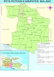
Pulau (island) Sempu is located about 70 kilometers south of the centre of Malang city, East Java. Technically, this island is a nature reservation under the jurisdiction of the BKSDA IV (natural resources conservation station) in Malang. While from a government administrative point of view the area is included in the Biru Settlement. Tambakrejo Village, Sumbermanjing Wetan Sub-District, Regency of Malang, of East Java.
The area of the island stretches 3.9 kilometers from east to west, and 3.6 kilometers from north to south. The topography of the island is for almost 50% made up of hilly plains, with slopes ranging from average to steep, at altitudes of 50 to 100 metres above sea level. The larger part of the beaches aligned with steep lime rock cliffs, which is is the characteristic of the islands along the Indian Ocean.
This character is also specific for the islands along the south and east of Java Island. Certainly, such terrain makes it difficult for the fishermen to moor their boats. But, such a condition also decides that the Sendang Biru Beach, which is located north of Sempu isalnd, has quiet waves. because of that, this beach is the safest harbour along the southern stretch of the Indian Ocean, and is the largest fish landing spot along the southern beach of Java Island.
The merits of Pulau Sempu for the fishermen of Sendang Biru Beach are indeed invaluable. Its sturdy shape with steep cliffs, neutralize the vicious waves of the southern seas. So it is not surprising to sometimes find fishermen performing the slalom test on this 3.9 kilometers long beach with its quiet waters.
Natural Cave
Pulau Sempu is separated from Java Island only by a 800 metres wide strait, which is also used as the gate to the open sea. Its waves are relatively quiet, appropriate for fishing, rowing, or swimming. As according to the land maps, the type of soil in the area of this island is of a litosol compound and reddish brown mediteran, and includes even the main limestone formation.
The only natural cave found on Pulau Sempu has its own specialty. The cave that is located around 2.5 kilometers from the Teluk (bay) Sumber Beach line is 25 metres above sea level and holds sources of sweet water. The cave is 20 metres long and 3 metres wide with a dry surface. It is highly strategic place for those who like to meditate, or just seek solitude.
Along the even steeper south side, there are also some sea caves. The sea caves along the east and southeast sides have become the settlements of numerous swallows. But, because of irs highly steep location, none of the local fishermen dare to pick the birds nests.
Safari Park
A visit to Pulau Sempu feels like being at the Bogor Safari Park. Wildlife like deers, black monkeys, boars, and panthers often teasingly cross the visitors paths. It is not surprising then that this area often provokes the hunter to cleave into its forests. According to the data at the Forest Office of East Java, the area still holds 12 species of mammals, 36 species of fowls, and 3 species of reptiles. With this variety of flora and fauna the management of the island, i.e. BKSDA IV in Malang, has developed the area into a tourist destination.
The other uniquenesses that can be found on this island, is the existence of two lakes, the lake Lele and Segara Anakan. At lake Lele a variety of colorful decorative fish can be found in abundance. While from Segara Anakan one can freely enjoy a view of the open sea.
You won’t encounter any problems getting to these lakes, because the Malang BKSDA IV has built footpaths from Teluk Semut. While to get to lake Lele, a 2.3 kilometers long footpaths has been built from Teluk Waru and Pantai Pasir Putih, which can be covered on foot in 2 hours.
Besides all those uniquenesses, Pulau Sempu also holds other tourist attractions like Pantai Pasir Putih, which is the gate to this island. The natural scenery at Pantai Pasir Putih is also not less fascinating. From here you can see clearly all of the fishermen’s activities. A variety of boats with its range of decorations can be seen coming and going to the open sea. And when dusk falls, the process of the sun setting into the horizon, can also be seen from this bright white sand beach. It is also along Pantai Pasir Putih that the visitor’s boats are moored before they continue the journey to Pulau Sempu.
Although its status is a nature reservation, the management of Pulau Sempu has changed this into an eco-tourist destination of East Java. This is in line indeed with the condition which holds feasible tourism potential to be offered to tourists. And when compared to the other eco-tourist destinations, Pulau Sempu indeed still feels natural. But, it is that genuinity that leaves this island feasible as an ecotourist destination, at the same time a place to preserve the wildlife in it.

